Forecasts For The 2012 Atlantic Hurricane Season
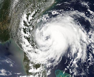 The 2012 Atlantic hurricane season is officially underway. With two early season storms, Alberto and Beryl, having already come and gone, this year’s season has gotten off to a near-record early start. Since reliable record keeping began in 1851, only the hurricane seasons of 1908 and 1887 had two named storms form so early in the year. So, will this early pace continue? What will this year’s hurricane season bring?
Here are my top five questions for the coming season:
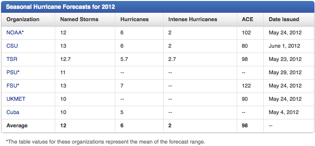
1.All of the major seasonal hurricane forecasts are calling for a near-average season, with 10 – 13 named storms. Will these pre-season predictions pan out?
2.How will the steering current pattern evolve? Will the U.S. break its six-year run without a major hurricane landfall, the longest such streak since 1861 - 1868?
3.Will the 420,000 people still homeless in Haiti in the wake of the January 2010 earthquake dodge a major tropical cyclone flooding disaster for the third consecutive hurricane season?
4.How will new National Hurricane Center director Rick Knabb fare in his inaugural season?
5.Will the Republican National Convention, scheduled to occur in Tampa during the last week of August, get interrupted by a tropical storm or hurricane?
Quick summary of the early-season atmosphere/ocean conditions in the Atlantic
Strong upper-level winds tend to create a shearing force on tropical storms (wind shear), which tears them apart before they can get going. In June, two branches of the jet stream, the polar jet to the north, and a subtropical jet to the south, typically bring high levels of wind shear to the Atlantic. The southern subtropical jet currently lies over the Caribbean, and is expected to remain there the next two weeks, making development unlikely in the Caribbean. Between the subtropical jet to the south and the polar jet to the north, a “hole” in the wind shear pattern formed during May off the Southeast U.S. coast, and this is where both Alberto and Beryl were able to form. Their formation was aided by the fact ocean temperatures off the U.S. East coast are quite warm–about 1 – 2°C above average. A wind shear “hole” is predicted to periodically open up during the next two weeks off the Southeast U.S. coast, making that region the most likely area of formation for any first-half-of-June tropical storms. However, none of the reliable computer models are predicting tropical storm formation in the Atlantic between now and June 8.
May ocean temperatures in the tropical Atlantic are approximately the third coolest we’ve seen since the current active hurricane period began in 1995. SSTs in the Main Development Region (MDR), between 10 – 20°N latitude, from the coast of Africa to the Central America, were about 0.35°C above average in May, according to NOAA’s Coral Reef Watch. Tropical storm activity in the Atlantic is strongly dependent on ocean temperatures in this region, and the relatively cool temperatures imply that we should see a delayed start to development of tropical waves coming off the coast of Africa and moving into the Caribbean, compared to the period 1995 – 2011. An interesting feature of this month’s SST departure from average image (Figure 2) is the large area of record-warm ocean temperatures off the mid-Atlantic and New England coasts, from North Carolina to Massachusetts. Ocean temperatures are 3 – 5°C (5 – 9°F) above average in this region. This makes waters of much above-average warmth likely to be present during the peak part of hurricane season, increasing the chances for a strong hurricane to affect the mid-Atlantic and New England coast.
The upper-level jet stream pattern is critical for determining where any tropical storms and hurricanes that form might go. Presently, these “steering currents” are in a typical configuration for June, favoring a northward or northeastward motion for any storms that might form. However, steering current patterns are fickle and difficult to predict more that seven days in advance, and there is no telling how the steering current pattern might evolve this hurricane season. We might see a pattern like evolved during 2004 – 2005, with a westward-extending Bermuda High, forcing storms into Florida and the Gulf Coast. Or, we might see a pattern like occurred during 2010 – 2011, with the large majority of the storms recurving harmlessly out to sea. That’s about as helpful as a weather forecast of “Sho’ enough looks like rain, lessen’ of course it clears up,” I realize.
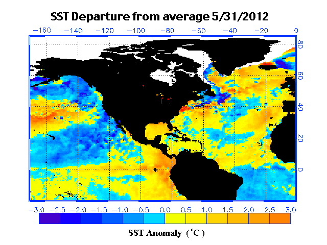
Figure 2. Departure of sea surface temperature from average for May 31, 2012.
Colorado State predicts a slightly above-average hurricane season
A slightly above-average Atlantic hurricane season is on tap for 2012, according to the seasonal hurricane forecast issued June 1 by Dr. Phil Klotzbach and Dr. Bill Gray of Colorado State University (CSU). The CSU team is calling for 13 named storms, 5 hurricanes, and 2 intense hurricanes, and an Accumulated Cyclone Energy (ACE) of 80, which is 87% of average. This is very close to the 1981 – 2010 average of 12 named storms, 6 hurricanes, and 3 major hurricanes. Hurricane seasons during the active hurricane period 1995 – 2011 have averaged 15 named storms, 8 hurricanes, and 4 major hurricanes, with an ACE index 153% of the median. The forecast calls for an average chance of a major hurricane hitting the U.S., both along the East Coast (28% chance, 31% chance is average) and the Gulf Coast (28% chance, 30% chance is average). The risk of a major hurricane in the Caribbean is also average, at 39% (42% is average.) The CSU teams expects we will have a weak El Niño develop by the peak of this year’s hurricane season in September, which will cut down on this year’s activity by increasing wind shear over the Tropical Atlantic. However, there is considerable uncertainty in this outlook.
Analogue years
The CSU team picked four previous years when atmospheric and oceanic conditions were similar to what we are seeing this year: neutral El Niño conditions in April – May and average tropical Atlantic and far North Atlantic SSTs during April – May, followed by August – October periods that were generally characterized by weak El Niño conditions and average tropical Atlantic SSTs . Those four years were 2009, a quiet El Niño year with only 3 hurricanes; 2001, which featured two major Caribbean hurricanes, Iris and Michelle; 1968, a very quiet year with no hurricanes stronger than a Category 1; and 1953, a moderately busy year with 14 named storms, 6 hurricanes, and 4 intense hurricanes. The mean activity for these four years was 11.5 named storms, 6 hurricanes, and 2.5 intense hurricanes.
How accurate are the June forecasts?
The June forecasts by the CSU team between 1998 and 2009 had a skill 19% – 30% higher than a “no-skill” climatology forecast for number of named storms, number of hurricanes, and the ACE index (Figure 3). This is a decent amount of skill for a seasonal forecast, and these June forecasts can be useful to businesses such as the insurance industry and oil and gas industry that need to make bets on how active the coming hurricane season will be. Unfortunately, the CSU June 1 forecasts do poorly at forecasting the number of major hurricanes (only 3% skill), and major hurricanes cause 80% – 85% of all hurricane damage (normalized to current population and wealth levels.) This year’s June forecast uses a brand new formula tried in 2011 for the first time, so there is no way to evaluate its performance. An Excel spreadsheet of their forecast skill (expressed as a mathematical correlation coefficient) show values from 0.41 to 0.62 for their June forecasts made between 1984 and 2010, which is respectable.
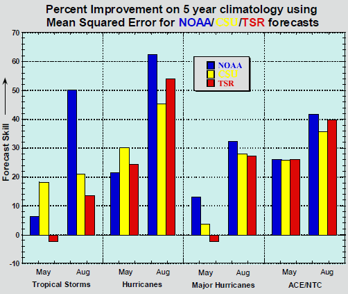
Figure 3. Comparison of the percent improvement over climatology for May and August seasonal hurricane forecasts for the Atlantic from NOAA, CSU and TSR from 1999-2009 (May) and 1998-2009 (August), using the Mean Squared Error. Image credit: Verification of 12 years of NOAA seasonal hurricane forecasts, National Hurricane Center.
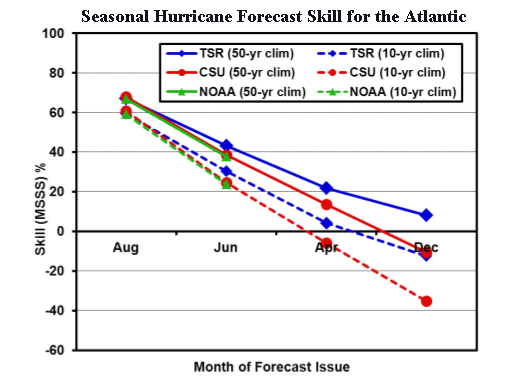
Figure 4. Comparison of the percent improvement in mean square error over climatology for seasonal hurricane forecasts for the Atlantic from NOAA, CSU and TSR from 2002-2011, using the Mean Square Skill Score (MSSS). The figure shows the results using two different climatologies: a fixed 50-year (1950 – 1999) climatology, and a 2002 – 2011 climatology. Skill is poor for forecasts issued in December and April, moderate for June forecasts, and good for August forecasts. Image credit: Tropical Storm Risk, Inc.
TSR predicts a near-average hurricane season
The British private forecasting firm Tropical Storm Risk, Inc. (TSR) calls for 12.7 named storms, 5.7 hurricanes, 2.7 intense hurricanes, and an Accumulated Cyclone Energy (ACE) of 98, which is near average. TSR rates their skill level as 23 – 27% higher than a “no-skill” forecast made using climatology, though an independent assessment by the National Hurricane Center (Figure 3) gives them somewhat lower skill numbers, using a different metric than TSR uses. TSR predicts a 48% chance that U.S. landfalling activity will be above average, a 26% chance it will be near average, and a 26% chance it will be below average. TSR’s two predictors for their statistical model are the forecast July-September trade wind speed over the Caribbean and tropical North Atlantic, and the forecast August-September 2012 sea surface temperatures in the tropical North Atlantic.
TSR projects that 3.6 named storms will hit the U.S., with 1.6 of these being hurricanes. The averages from the 1950-2011 climatology are 3.1 named storms and 1.5 hurricanes. They rate their skill at making these June forecasts for U.S. landfalls at 7 – 11% higher than a “no-skill” forecast made using climatology. In the Lesser Antilles Islands of the Caribbean, TSR projects 1.2 named storms, 0.5 of these being hurricanes. Climatology is 1.1 named storms and 0.5 hurricanes.
FSU predicts a slightly above-average hurricane season: 13 named storms
The Florida State University (FSU) Center for Ocean-Atmospheric Prediction Studies (COAPS) issued their fourth annual Atlantic hurricane season forecast, calling for a 70% probability of 10 – 16 named storms and 5 – 9 hurricanes. The mid-point forecast is for 13 named storms, 7 hurricanes, and an accumulated cyclone energy (ACE) of 122. The scientists use a numerical atmospheric model developed at COAPS to understand seasonal predictability of hurricane activity. The model is one of only a handful of numerical models in the world being used to study seasonal hurricane activity and is different from the statistical methods used by other seasonal hurricane forecasters such as Colorado State, TSR, and PSU (NOAA uses a hybrid statistical-dynamical model technique.) The FSU forecast has been the best one over the past three years, for predicting numbers of Atlantic named storms and hurricanes:
2009 prediction: 8 named storms, 4 hurricanes. Actual: 9 named storms, 3 hurricanes
2010 prediction: 17 named storms, 10 hurricanes. Actual: 19 named storms, 9 hurricanes
2011 prediction: 17 named storms, 9 hurricanes. Actual: 19 named storms, 7 hurricanes
Penn State predicts a near-average hurricane season: 11 named storms
A statistical model by Penn State’s Michael Mann and alumnus Michael Kozar is calling for an average Atlantic hurricane season with 11.2 named storms, plus or minus 3.3 storms. Their prediction was made using statistics of how past hurricane seasons have behaved in response to sea surface temperatures (SSTs), the El Niño/La Niña oscillation, the North Atlantic Oscillation (NAO), and other factors. The statistic model assumes that in 2012 the current 0.35°C above average temperatures in the MDR will persist throughout hurricane season, the El Niño phase will be neutral to slightly warm, and the North Atlantic Oscillation (NAO) will be near average.
The PSU team has been making Atlantic hurricane season forecasts since 2007, and these predictions have done pretty well:
2007 prediction: 15 named storms, Actual: 15
2009 prediction: 12.5, named storms, Actual: 9
2010 prediction: 23 named storms, Actual: 19
2011 prediction: 16 named storms, Actual: 19
UK Met Office predicts a slightly below-average hurricane season: 10 named storms
The UK Met Office uses a combination of their Glosea4 model and the ECMWF system 4 model to predict seasonal hurricane activity. These dynamical numerical models are predicting a slightly below-average season, with 10 named storms and an ACE index of 90.
NOAA predicts an average hurricane season: 12 named storms
As I discussed in detail in a May 24 blog post, NOAA is calling for 12 named storms, 6 hurricanes, 2 major hurricanes, and an ACE index 102% of normal.
NOAA predicts an average Eastern Pacific hurricane season
NOAA’s pre-season prediction for the Eastern Pacific hurricane season, issued on May 24, calls for a near-average season, with 12 -18 named storms, 5 – 9 hurricanes, 2 – 5 major hurricanes, and an ACE index 70% – 130% of the median. The mid-point of these ranges gives us a forecast for 15 named storms, 7 hurricanes, and 3.5 major hurricanes, with an ACE index exactly average. The 1981 – 2010 averages for the Eastern Pacific hurricane season are 15 named storms, 8 hurricanes, and 4 major hurricanes. So far in 2012, there have been two named storms. On average, the 2nd storm of the year doesn’t form until June 25. We had a record early appearance of the season’s second named storm (Bud on May 21.) Bud was also the strongest Eastern Pacific hurricane on record for so early in the year. Records in the Eastern Pacific extend back to 1949.
Western Pacific typhoon season forecast not available yet
Dr. Johnny Chan of the City University of Hong Kong issues a seasonal forecast of typhoon season in the Western Pacific, but this forecast is not yet available (as of June 1.) An average typhoon season has 27 named storms and 17 typhoons. Typhoon seasons immediately following a La Niña year typically see higher levels of activity in the South China Sea, especially between months of May and July. Also, the jet stream tends to dip farther south than usual to the south of Japan, helping steer more tropical cyclones towards Japan and Korea. With the formation of Tropical Storm Mawar today east of the Philippines, the Western Pacific is exactly on the usual climatological pace for formation of the season’s third storm.
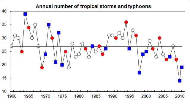
Figure 5. Time series of the annual number of tropical storms and typhoons in the Northwest Pacific from 1960 – 2011. Red circles and blue squares indicate El Niño and La Niña years, respectively. Note that La Niña years tend to have lower activity, with 2010 having the lowest activity on record (15 named storms.) In 2011, there were 20 named storms. The thick horizontal line indicates the normal number of named storms (27.)
You can return to the main Market News page, or press the Back button on your browser.

