
Unprecedented Event Since Modern U.S. Weather Records Began In The Late 19th Century'
March Heat Records Hit Incredible Ratio of 35 to 1 vs. Cold Records, Must-See Weather Channel Video Explains Link to Global Warming
Dr. Jeff Masters: A spring heat wave like no other in U.S. and Canadian history peaked in intensity yesterday, during its tenth day. Since record keeping began in the late 1800s, there have never been so many temperature records broken for spring warmth in a one-week period–and the margins by which some of the records were broken yesterday were truly astonishing. Wunderground’s weather historian, Christopher C. Burt, commented to me yesterday, “it’s almost like science fiction at this point.”
Yesterday, meteorologist Masters published a detailed statistical analysis that concluded, “It is highly unlikely the warmth of the current ‘Summer in March’ heat wave could have occurred unless the climate was warming.”
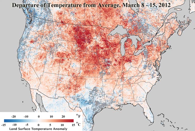
Based on satellite data, the map depicts temperatures from March 8–15 compared to the average of the same eight day period of March from 2000-2011. Image: NASA via Masters.
Among the stunning records set yesterday are:
Pellston, MI: record high broken by 32°F
Low temperatures beat the previous record high for the date at two stations
Multiple Canadian cites break all-time April records for warmth in March
This off-the-charts event is just what scientists have been warning to expect if we kept spewing billions of tons of heat-trapping greenhouse gases into the air (see Hansen et al: “Extreme Heat Waves … in Texas and Oklahoma in 2011 and Moscow in 2010 Were ‘Caused’ by GlobalWarming”).
Meteorologists and science writers have been struggling to come up with words to describe this super-charged heat wave: “This is not the atmosphere I grew up with” and it’s “not just breaking but obliterating records” and “OFF THE SCALE WEIRD; even for Minnesota.” Climate Central wrote:
In fact, the broad geographic scope of this heat event, along with the margins by which records are being broken, the time of year this is occurring, and the duration of the event are all indications that this may be an unprecedented event since modern U.S. weather records began in the late 19th century.
Like a baseball player on steroids, our climate system is breaking records at an unnatural pace. Weather Channel meteorologist Stu Ostro calls the current heat wave “surreal” and explained that “While natural factors are contributing to this warm spell, given the nature of it and its context with other extreme weather events and patterns in recent years there is a high probability that global warming is having an influence upon its extremity.”
There is a must-see interview of Ostro on the Weather Channel’s website, in which he explains how “data and science” — see this big PDF – switched him from being a skeptic on climate change to someone who understands that humans are changing the climate now:
Weather Channel meteorologists are stunned by “the sheer number of daily record highs either tied or broken over the past two weeks” as they explain in their post, “Perspective: More than 4,000 Record Highs Set!”:
If you pull out your calculator and add the numbers up from March 9 to March 19, the total exceeds 4,300!! This speaks to the widespread nature and longevity of this warm spell….
Through March 21, International Falls, Minn., self-promoted as the “Icebox of the Nation”, has tied or broken daily record highs 11 of the past 12 days!
… Chicago, Ill. set record highs eight days in a row through Wednesday! In this streak, seven of the days have been in the 80s, including Wednesday’s astounding 87 degree high! The National Weather Service in Chicago recently called the warm spell “historic” and something that is unlikely to be matched in our lifetime.
We have entered the age of the exclamation point.
But the notion that this won’t be matched in our lifetime is to miss the impact global warming is having on heat records, according to the scientific literature.
Yes, this March U.S. heat records have been outnumbering cold records by a stunning amount – an incredible 35-to-1 – as this chart from Steve Scolnik at Capital Climate makes clear:
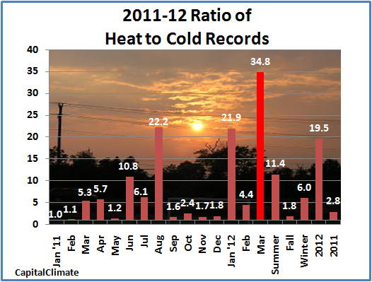
Monthly ratio of daily high temperature to low temperature records set in the U.S. for every month of 2011 and the first half of March, seasonal ratio for summer and fall 2011, winter 2011-2012 to date, and annual ratio for 2011 and 2012, data from NOAA.
Scolnick notes, “For the year to date, the ratio is approaching 20 to 1, nearly 10 times the pace of the previous decade.”
I like the statistical aggregation across the country, since it gets us beyond the oft-repeated point that you can’t pin any one record temperature on global warming. If you want to know the historical ratios, see the 2009 analysis, “Record high temperatures far outpace record lows across U.S.,” which shows that the average ratio for the 2000s was 2.04-to-1, a sharp increase from previous decades. Gerald Meehl, the lead author and a senior scientist at the National Center for Atmospheric Research (NCAR), explained, “If temperatures were not warming, the number of record daily highs and lows being set each year would be approximately even.”
The key point is that NCAR found:
The modeling results indicate that if nations continue to increase their emissions of greenhouse gases in a “business as usual” scenario, the U.S. ratio of daily record high to record low temperatures would increase to about 20-to-1 by mid-century and 50-to-1 by 2100. The mid-century ratio could be much higher if emissions rose at an even greater pace….
In fact, emissions are rising at a faster rate than expected. So business as usual means that by mid-century, the ‘normal’ ratio could be even higher than 20-to-1, which is just what we have seen this year to date. So what is an off-the-charts March now, could be a pretty common event by, say, the 2040s. A great many people alive today will see this happen again — and many will see even worse.
Here are some more remarkable records from Wednesday, via Masters:
Pellston, MI: record high broken by 32°F
Pellston, Michigan in the Northern Lower Peninsula is called “Michigan’s Icebox”, since it frequently records the coldest temperatures in the state, and in the entire nation. But the past five days, Pellston has set five consecutive records for hottest March day. Yesterday’s 85° reading broke the previous record for the date (53° in 2007) by a ridiculous 32°, and was an absurd 48°F above average.
Low temperatures beat the previous record high for the date at two stations
The low temperature at Marquette, Michigan was 52° yesterday, which was 3° warmer than the previous record high for the date! The low at Mt. Washington, NH yesterday (44°) also beat the previous record high for the date (43°.)
Multiple Canadian cites break all-time April records for warmth in March
Not only was yesterday the warmest March day in recorded history for many of Canada’s major cities, it was also warmer than any April day at many locations. St. John, New Brunswick hit 25.4°C (78°F.) Not only did this crush the record high for March (previous record: 17.5°C), it is well above any temperature ever measured in April (extreme April temperature on record: 22.8°C.) Halifax, Nova Scotia hit 25.8°C yesterday, beating their all-time March record of 25.6°, and their all-time April record of 26.3°C, set on April 30, 2004. Other major cities in Canada that set all-time warmest March records yesterday included Ottawa (27.4°C), Montreal (25.8°C), Windsor (27.8°C), Hamilton (25.6°C), London (26.4°C), and Fredericton (27.1°C)….
Summer in March warmth crushes records in Michigan
Yesterday, nearly every major airport in Michigan’s Lower Peninsula broke the record they set the previous day for their hottest March temperature, including Detroit (84°), Flint (86°F, just 2° below their all-time April record), Saginaw (87°F, just 2° below their all-time April record), Grand Rapids (87°), Muskegon (82°), Lansing (86°), Alpena (87°), Gaylord (83°, which was 26° above the average high for the date), Pellston (85°), Houghton Lake (85°), and Traverse City (87°, which was which was 45°F above the average high for the date, and was the fifth consecutive day they tied or broke their record for hottest March temperature, and just 3° below their record high temperature of 90° for April.) In Michigan’s Upper Peninsula, Sault Ste. Marie’s 83° (26° above the average high for the date) crushed the previous March record by 8°, and was only 2° shy of the warmest temperature ever measured in April.
Again, we’ve only warmed about a degree and a half Fahrenheit in the past century. We are on track to warm five times times that or more this century (see M.I.T. doubles its 2095 warming projection to 10°F — with 866 ppm and Arctic warming of 20°F ).
In short, we ain’t seen nothing yet!
Dr. Jeff Masters: A spring heat wave like no other in U.S. and Canadian history peaked in intensity yesterday, during its tenth day. Since record keeping began in the late 1800s, there have never been so many temperature records broken for spring warmth in a one-week period–and the margins by which some of the records were broken yesterday were truly astonishing. Wunderground’s weather historian, Christopher C. Burt, commented to me yesterday, “it’s almost like science fiction at this point.”
Yesterday, meteorologist Masters published a detailed statistical analysis that concluded, “It is highly unlikely the warmth of the current ‘Summer in March’ heat wave could have occurred unless the climate was warming.”
Based on satellite data, the map depicts temperatures from March 8–15 compared to the average of the same eight day period of March from 2000-2011. Image: NASA via Masters.
Among the stunning records set yesterday are:
Pellston, MI: record high broken by 32°F
Low temperatures beat the previous record high for the date at two stations
Multiple Canadian cites break all-time April records for warmth in March
This off-the-charts event is just what scientists have been warning to expect if we kept spewing billions of tons of heat-trapping greenhouse gases into the air (see Hansen et al: “Extreme Heat Waves … in Texas and Oklahoma in 2011 and Moscow in 2010 Were ‘Caused’ by GlobalWarming”).
Meteorologists and science writers have been struggling to come up with words to describe this super-charged heat wave: “This is not the atmosphere I grew up with” and it’s “not just breaking but obliterating records” and “OFF THE SCALE WEIRD; even for Minnesota.” Climate Central wrote:
In fact, the broad geographic scope of this heat event, along with the margins by which records are being broken, the time of year this is occurring, and the duration of the event are all indications that this may be an unprecedented event since modern U.S. weather records began in the late 19th century.
Like a baseball player on steroids, our climate system is breaking records at an unnatural pace. Weather Channel meteorologist Stu Ostro calls the current heat wave “surreal” and explained that “While natural factors are contributing to this warm spell, given the nature of it and its context with other extreme weather events and patterns in recent years there is a high probability that global warming is having an influence upon its extremity.”
There is a must-see interview of Ostro on the Weather Channel’s website, in which he explains how “data and science” — see this big PDF – switched him from being a skeptic on climate change to someone who understands that humans are changing the climate now:
Weather Channel meteorologists are stunned by “the sheer number of daily record highs either tied or broken over the past two weeks” as they explain in their post, “Perspective: More than 4,000 Record Highs Set!”:
If you pull out your calculator and add the numbers up from March 9 to March 19, the total exceeds 4,300!! This speaks to the widespread nature and longevity of this warm spell….
Through March 21, International Falls, Minn., self-promoted as the “Icebox of the Nation”, has tied or broken daily record highs 11 of the past 12 days!
… Chicago, Ill. set record highs eight days in a row through Wednesday! In this streak, seven of the days have been in the 80s, including Wednesday’s astounding 87 degree high! The National Weather Service in Chicago recently called the warm spell “historic” and something that is unlikely to be matched in our lifetime.
We have entered the age of the exclamation point.
But the notion that this won’t be matched in our lifetime is to miss the impact global warming is having on heat records, according to the scientific literature.
Yes, this March U.S. heat records have been outnumbering cold records by a stunning amount – an incredible 35-to-1 – as this chart from Steve Scolnik at Capital Climate makes clear:
Monthly ratio of daily high temperature to low temperature records set in the U.S. for every month of 2011 and the first half of March, seasonal ratio for summer and fall 2011, winter 2011-2012 to date, and annual ratio for 2011 and 2012, data from NOAA.
Scolnick notes, “For the year to date, the ratio is approaching 20 to 1, nearly 10 times the pace of the previous decade.”
I like the statistical aggregation across the country, since it gets us beyond the oft-repeated point that you can’t pin any one record temperature on global warming. If you want to know the historical ratios, see the 2009 analysis, “Record high temperatures far outpace record lows across U.S.,” which shows that the average ratio for the 2000s was 2.04-to-1, a sharp increase from previous decades. Gerald Meehl, the lead author and a senior scientist at the National Center for Atmospheric Research (NCAR), explained, “If temperatures were not warming, the number of record daily highs and lows being set each year would be approximately even.”
The key point is that NCAR found:
The modeling results indicate that if nations continue to increase their emissions of greenhouse gases in a “business as usual” scenario, the U.S. ratio of daily record high to record low temperatures would increase to about 20-to-1 by mid-century and 50-to-1 by 2100. The mid-century ratio could be much higher if emissions rose at an even greater pace….
In fact, emissions are rising at a faster rate than expected. So business as usual means that by mid-century, the ‘normal’ ratio could be even higher than 20-to-1, which is just what we have seen this year to date. So what is an off-the-charts March now, could be a pretty common event by, say, the 2040s. A great many people alive today will see this happen again — and many will see even worse.
Here are some more remarkable records from Wednesday, via Masters:
Pellston, MI: record high broken by 32°F
Pellston, Michigan in the Northern Lower Peninsula is called “Michigan’s Icebox”, since it frequently records the coldest temperatures in the state, and in the entire nation. But the past five days, Pellston has set five consecutive records for hottest March day. Yesterday’s 85° reading broke the previous record for the date (53° in 2007) by a ridiculous 32°, and was an absurd 48°F above average.
Low temperatures beat the previous record high for the date at two stations
The low temperature at Marquette, Michigan was 52° yesterday, which was 3° warmer than the previous record high for the date! The low at Mt. Washington, NH yesterday (44°) also beat the previous record high for the date (43°.)
Multiple Canadian cites break all-time April records for warmth in March
Not only was yesterday the warmest March day in recorded history for many of Canada’s major cities, it was also warmer than any April day at many locations. St. John, New Brunswick hit 25.4°C (78°F.) Not only did this crush the record high for March (previous record: 17.5°C), it is well above any temperature ever measured in April (extreme April temperature on record: 22.8°C.) Halifax, Nova Scotia hit 25.8°C yesterday, beating their all-time March record of 25.6°, and their all-time April record of 26.3°C, set on April 30, 2004. Other major cities in Canada that set all-time warmest March records yesterday included Ottawa (27.4°C), Montreal (25.8°C), Windsor (27.8°C), Hamilton (25.6°C), London (26.4°C), and Fredericton (27.1°C)….
Summer in March warmth crushes records in Michigan
Yesterday, nearly every major airport in Michigan’s Lower Peninsula broke the record they set the previous day for their hottest March temperature, including Detroit (84°), Flint (86°F, just 2° below their all-time April record), Saginaw (87°F, just 2° below their all-time April record), Grand Rapids (87°), Muskegon (82°), Lansing (86°), Alpena (87°), Gaylord (83°, which was 26° above the average high for the date), Pellston (85°), Houghton Lake (85°), and Traverse City (87°, which was which was 45°F above the average high for the date, and was the fifth consecutive day they tied or broke their record for hottest March temperature, and just 3° below their record high temperature of 90° for April.) In Michigan’s Upper Peninsula, Sault Ste. Marie’s 83° (26° above the average high for the date) crushed the previous March record by 8°, and was only 2° shy of the warmest temperature ever measured in April.
Again, we’ve only warmed about a degree and a half Fahrenheit in the past century. We are on track to warm five times times that or more this century (see M.I.T. doubles its 2095 warming projection to 10°F — with 866 ppm and Arctic warming of 20°F ).
In short, we ain’t seen nothing yet!
You can return to the main Market News page, or press the Back button on your browser.