
Exceptional June rain soaks Pacific Northwest due to atmospheric river
 Normally by June, the Pacific Northwest has entered its dry season, and the skies above Seattle and Portland are sparkling blue. But Thursday was a throwback to the dark, damp days of winter as an intense atmospheric river unloaded drenching rains.
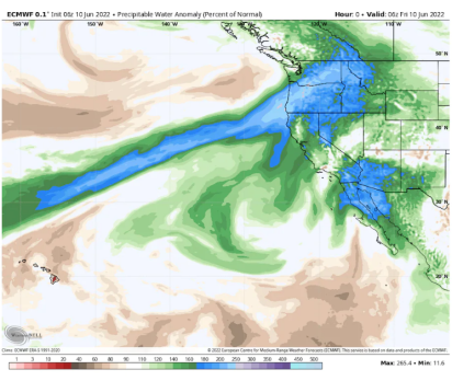
The atmospheric river — a narrow strip of deep moisture sourced from the tropics — was classified as a Category 5 on the 1-to-5 scale developed by the Center for Western Weather and Water Extremes in San Diego. During the winter, these rivers in the sky are responsible for a large percentage of the rain and snow in the western United States.
“It’s remarkably unusual to have an AR5 (Category 5 atmospheric river) in June in the Northwest,” said Marty Ralph, who directs the center.
The resulting rainfall totals have set records in numerous instances and led to sharp rises and fast flows on area waterways. The rains are even expected to push the Columbia River near Portland close to flood stage by Sunday and Monday — its highest level since spring 2019.
The National Weather Service office in Seattle reported that all of its climate-monitoring sites established new rainfall records for June 9 on Thursday, each posting between 1 and 2 inches of rain, including Seattle, Olympia, Bellingham, Quillayute and Hoquiam.
Each of the sites notched one of its 15 wettest June days, including Seattle-Tacoma International Airport, where the 1.1 inches that fell marked its sixth wettest total during the month. The airport has received 2.17 inches so far the month, the 17th most on record, with 20 days remaining.
Higher amounts fell in the Olympic Mountains — with up to 2.5 to 3 inches reported.
Western Oregon was also soaked. Astoria registered 1.23 inches, shattering its previous June 9 record of 0.72 inches.
The clouds and rain have depressed temperatures. Seattle’s high on Thursday was just 59 degrees — 11 degrees below average — and more typical of early spring.
The rainy, cool conditions in the Pacific Northwest are in stark contrast to the Desert Southwest, where record-high temperatures of over 110 degrees are forecast for Friday and Saturday.
The Weather Service in Seattle described the rain as “seasonally unusual” in a forecast discussion. As the rain approached early Thursday and weather satellite imagery revealed a 2,000-mile fetch of moisture pointed at the region, the Weather Service tweeted: “No, we didn’t save this satellite loop from January.”
While the bulk of the rain has already fallen in western Washington and Oregon, heavy downpours are still slated to pass through central and eastern portions of the two states.
Flood watches are in effect for a number of areas in central Washington through Sunday, including the Yakima Valley and the east slopes of the Washington Cascades. About 0.5 to 1.5 inches of rain is projected in this zone, with up to 2 to 3 inches at higher elevations.
The Weather Service office in Pendleton, Ore., wrote that the Naches River in south-central Washington is expected to be most affected by the downpours and could swell to moderate flood stage over the weekend.
“Heavier rain expected Friday night into Saturday, combined with continued snowmelt, will make for flood concerns along the east slopes, especially along the Naches,” the Weather Service wrote.
As air flow remains off the ocean, damp conditions are expected to persist over the Pacific Northwest into early next week. By the middle of next week, somewhat warmer and drier weather is predicted to return. More rain, however, is possible in another week.
Although this atmospheric river event has brought damp, dreary weather and potential flooding to the Pacific Northwest, Ralph said there are benefits.
“This will delay the onset of the fire risk season,” he said. “The shorter the fire season, the better.”
You can return to the main Market News page, or press the Back button on your browser.