
Asian Cities endangered by climate change
Asia’s
coastal megacities will flood more often, on a larger scale, and
affect millions more people, if current climate change trends
continue, a new report warns.
The report target=”_blank”>Climate Risks and Adaptation in Asian Coastal
Megacities examines the impact of climate change on
Bangkok, Ho Chi Minh City, and Manila, under a range of different
scenarios through to 2050.
The report is the product of a two-year collaborative study by
the Asian Development Bank (ADB), the Japan International
Cooperation Agency (JICA) and the World Bank. It was released here
today at the Asia Pacific Climate Change Adaptation Forum.
The report finds that costs from major flooding events on
infrastructure and the economy could run into the billions of
dollars, with urban poor populations likely to be the hardest hit.
It concludes that all three cities need to take targeted,
city-specific and cutting edge approaches to meet these
challenges.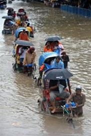
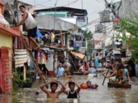
Bangkok, Ho Chi Minh City, and Manila all have populations close
to or over 10 million. Two are capital cities and all three are
centers of national and regional economic growth contributing
substantially to the GDP of the respective countries.
As coastal megacities, all face increased climaterelated risks
such as rising sea levels and an increased frequency of extreme
weather events. While commendable measures to counteract flooding
have already been taken by these cities, much more needs to be
done, the report argues.
For cities to address future climate related risks, sound urban
environmental management is crucial. Land subsidence due to
groundwater pumping, dumping of solid waste into city canals and
waterways, clogged drainage systems, and deforestation in the upper
watershed all contribute to
urban flooding. Better management of these urban environmental
issues will help manage future climate-related impacts.
Given the damage costs associated with climate change, the
report also recommends that governments of coastal megacities
undertake proactive measures to address climate risks as an
integral part of urban planning. This includes developing strategic
urban adaptation frameworks for
managing climate risks, strengthening institutional capacity for
adaptation and implementing measures such as land use planning and
zoning to help reduce urban vulnerability.
In Bangkok, flooding is caused by land subsidence and increased
rainfall in the large watershed that drains through the city.
Therefore, measures to control groundwater pumping, improve flood
forecasting and information, raise dikes and invest in pump station
capacity, are needed.
The threat from sea level rise and storm surges are found to be
less dramatic, but still warrant investment in coastal zone
protection and land use planning that takes a long-term perspective
on these factors.
 In Ho Chi
Minh City, the report states that around 26% of the population is
currently affected by extreme storm events, but those numbers could
climb to more than 60% by 2050.
The government has expressed interest in a climate change
adaptation plan for the city, which can provide an overall
framework for adaptation measures within relevant sectors.
Infrastructure-based approaches can also be usefully combined with
ecosystems-based approaches such as management of mangroves and
rehabilitation of urban wetlands.
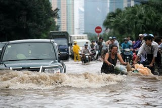
In Metro Manila, the report states that in the worst case
scenario a major flood could cause damage totaling almost a quarter
of the metropolitan area’s GDP. The main threats to Manila are
extreme rainfall, sea level rise, as well as more powerful
typhoons. The report suggests that continuous improvements and
redesigning of flood control infrastructure are necessary.
The report’s findings on the three cities are a bellwether for
coastal megacities around the world, from Asia to Africa. Its key
messages include the following:
i) Better management of urban
environment and infrastructure will help manage potential
climate-related impacts in coastal cities;
ii) Climate-related risks should be considered as an integral part
of city and regional planning; and
iii Targeted city-specific solutions, combining infrastructure
investment, zoning, and ecosystem-based strategies are
required.
The report can be downloaded from the
World
Bank websites
A related survey of climate change vulnerability is the
target=”_blank”>Climate Change Vulnerability Index, compiled
by a British-based global risks advisory firm, Maplecroft, is
intended as a guide for strategic investment and policymaking.
Its latest survey of 170 nations published on
Wednesday ranks South Asia is the world’s most climate-vulnerable
region, its fast-growing populations badly exposed to flood,
drought, storms and sea-level rise, according to a survey. Of the
16 countries listed as being at “extreme” risk from climate change
over the next 30 years, five are from South Asia, with Bangladesh
and India in first and second places, Nepal in fourth, Afghanistan
in eighth and Pakistan at 16th.
The picture of flooding in Hanoi on October 31, 2008, is by
href=”http://flickr.com/photos/52621576@N00”
class=”external text”>haithanh, Wikimedia Commons via Flickr,
under the
title=”w:Creative Commons” class=”extiw”>Creative Commons
class=”external text”>Attribution 2.0 License.
Source: www.adb.org
You can return to the main Market News page, or press the Back button on your browser.