New climate ‘normal’ for Atlantic hurricanes shows more frequent and intense storms
 Every 10 years, the National Oceanographic and Atmospheric Administration revises the baseline of what weather and climate conditions are considered “normal.” The most recent normals for Atlantic hurricane activity will soon be released, and a preview reveals a spike in storm frequency and intensity.
During the most recent 30-year period, which spans 1991 to 2020, there has been an uptick in the number of named storms and an increase in the frequency of major hurricanes of category 3 intensity or greater in the Atlantic.
That comes as no surprise amid a spate of extreme hurricane activity that has featured seven Category 5 storms swirling across Atlantic waters in just the past five years.
The newly revised climate normals aren’t a forecast of upcoming activity, nor are they necessarily illustrative of any one particular climate or meteorological trend. They’re simply benchmark values.

The National Weather Service calculates new climate normals each decade for all major U.S. cities with sufficient historical data. When you hear your local television meteorologist describe a day as “10 degrees above average,” for instance, this data is where that comes from.
The new hurricane normals are not official yet, though available data clearly shows an uptick in storm frequency and intensity, likely related to a combination of climate change, natural variability and improved storm detection.
“The 1991-2020 climate figures for hurricane season will be discussed, finalized and released in May,” said Dennis Feltgen, a meteorologist and public affairs specialist at the National Hurricane Center. The agency plans to coordinate with NOAA’s National Centers for Environmental Information and the Climate Prediction Center before releasing final tallies.
John Bateman, a meteorologist at NOAA’s Satellite and Information Service, said that “right now, what those normals say about Atlantic Basin hurricanes is still being reviewed.”
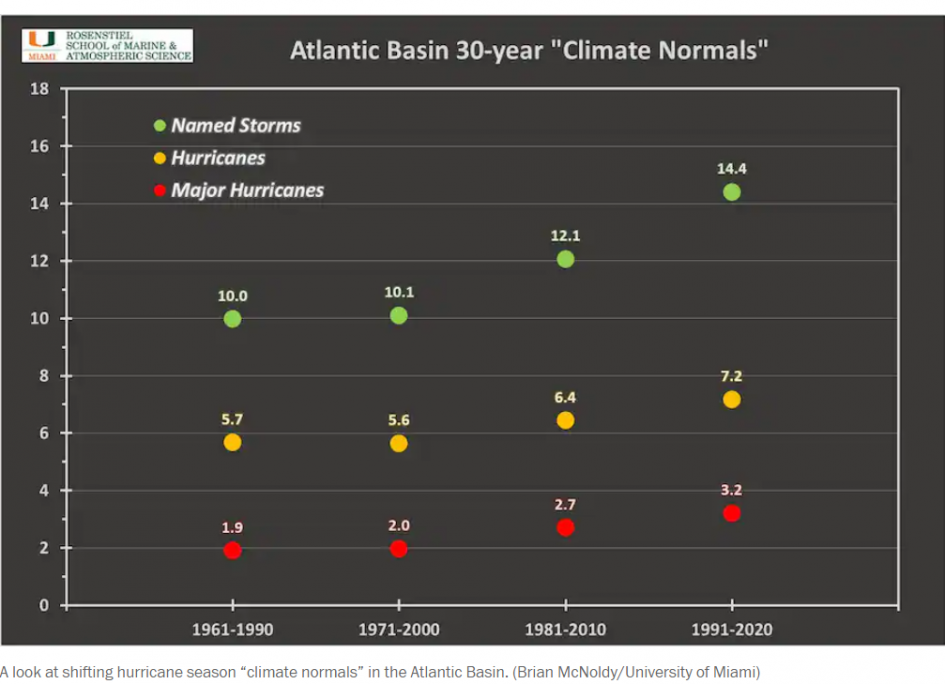
Between 1961 and 1990, the Atlantic averaged 10 named storms a year, including 1.9 major hurricanes. Those values remained essentially constant in the 1971-2000 climate period.
However, the figures began climbing in the 1981-2010 window, and have escalated significantly since.
Brian McNoldy, an atmospheric scientist, ran the calculations to preview what the Hurricane Center will probably report for the new normals. He found that an average of more than three major hurricanes have spun up each year since 1990, with roughly 14 named storms per year.
At first glance, it looks like a concerning spike, especially compared to the 1961-1990 period. But part of that increase, especially the count of named storms, may be the result of technological improvements that allow us to see more that may otherwise have been missed before the satellite era.
“I would not be too alarmed at the dramatic increase between the 1981-2010 averages and the 1991-2020 averages,” wrote McNoldy in an email. “Keep in mind that both sets have 1991-2010 in common, so we’re really comparing 1981-1990 to 2011-2020.”
McNoldy noted “a gradual increase in technology between the 1980s and the 2010s, especially in scatterometry,” which is a type of satellite-based imaging system that allows meteorologists to detect changes in storm structure and wind speeds.
That may be a key factor in the perceived increase in storm frequency, since it’s still an active area of research on whether climate change will significantly change the number of named storms that form. The science is clearer, however, that of the storms that form, they are expected to be more intense, with greater rainfall and higher wind speeds.
The new normals do show an increase in major hurricanes of category 3 intensity or greater.
“We could conceivably see little change in the number of named storms but still an increase in the number of major hurricanes in some future update,” McNoldy said.
McNoldy also highlighted other factors, like the AMO, or the Atlantic Multidecadal Oscillation. Some scientists say this theorized cycle influences ocean water temperatures and atmospheric features, and have linked it to Atlantic hurricane activity. They say that the Atlantic Basin has historically alternated between 25- to 40-year periods of cool and warmer sea surface temperatures and that the pendulum is currently closer to the warm side of the spectrum.
But not everyone agrees that the AMO exists, let alone is a driver of storm activity during a particular season.
Michael Mann, a climate scientist at Pennsylvania State University who was one of the earliest ones to theorize the AMO, now thinks it’s bunk.
“The attribution of rising hurricane activity to the ‘AMO’ (a term I coined back in 2000), i.e. a natural long-term climate oscillation, is simply wrong,” Mann said in an email. “As we have shown in the scientific literature, the warming that is behind the unprecedented recent Atlantic hurricane activity is tied to human-caused greenhouse warming, not natural variability.”
Working with other researchers, Mann issued a seasonal hurricane forecast last year that came the closest to predicting the actual number of hurricanes and major hurricanes, and it relied mainly on unusually mild waters in a particular part of the tropical Atlantic Ocean. “Forecasts that instead relied on the so-called ‘AMO’ didn’t fare as well, underscoring the flaw in linking Atlantic hurricane activity to a supposed natural AMO climate oscillation,” Mann said.
Of course, natural variability, or expected atmospheric randomness tied to patterns like El Niño and La Niña, is partly to blame, too. McNoldy says this is perhaps the biggest player in the jump in numbers.
“Simply, the 1981-1990 period included several very inactive seasons, while the 2011-2020 period included several very active seasons,” wrote McNoldy. “When one inactive decade drops out of the average and an active one takes its place, of course the average will go up.”
Looking ahead, there’s no guarantee the streak of busy seasons will continue at its current pace. But McNoldy says that calculating our averages around them is an important meteorological exercise.
“If the averages are not representative of a modern climate, then both the averages and the anomalies lose their meaning,” wrote McNoldy.
NOAA plans to officially release its updated averages in May, around the same time the agency issues its first long-range seasonal hurricane season outlook.
You can return to the main Market News page, or press the Back button on your browser.

