Earth just experienced the hottest May on record
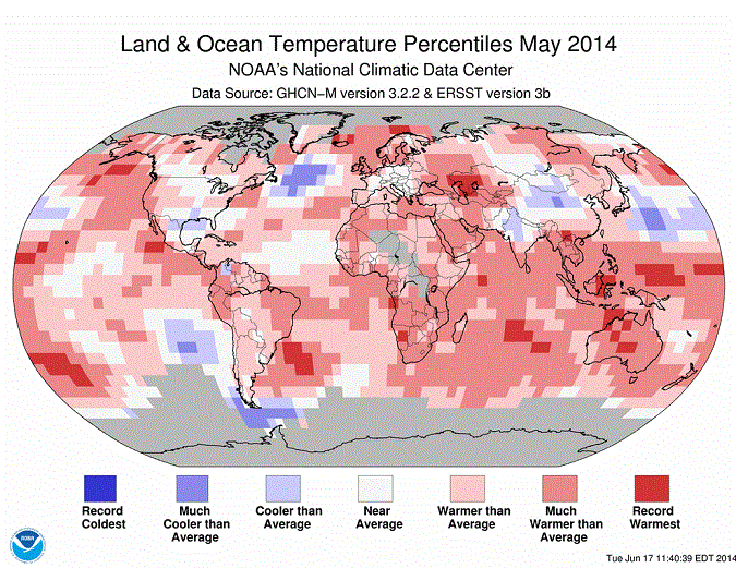
The world recently hit another hot milestone: May 2014 was the warmest May globally since records began in 1880.
That shouldn’t be entirely surprising. Climate scientists expect the Earth to get hotter over time as humans keep adding greenhouse gases to the atmosphere. Those scientists tend to emphasize long-term trends across years and decades — with lots of short-term variation. But if those trends hold, record hot months should become more common.
An interesting related question, meanwhile, is whether 2014 or 2015 could end up being the hottest year in the temperature record. Some scientists say this is very possible, particularly if El Niño conditions return in the Pacific Ocean, as expected. But a lot will depend on the timing and the type of El Niño that forms.
May 2014 was the hottest May on record

The average global temperature in May 2014 was 59.9°F, which was 1.3°F hotter than the May average for the entire twentieth century. That’s according to new data this week from the National Oceanic and Atmospheric Administration.
The January to May period in 2014, meanwhile, was the fifth-warmest since records began in 1880, NOAA said.
Earlier temperature analyses from both NASA and Japan’s meteorological agency also had May 2014 as the warmest May on record. By contrast, satellite data from John Christy of the University of Alabama in Huntsville pegged May 2014 as the third-warmest since satellite measurements began in 1978.
NOAA measures temperatures over both the land and the oceans. And the oceans were particularly noteworthy here — average sea surface temperatures were 62.36°F last month, a new record for May, and one of the biggest departures from the long-term monthly average for any month on record.
Climatologists will be watching the oceans closely in the months ahead. NOAA now projects there’s a 70 percent chance of an El Niño forming by the summer of 2014 and an 80 percent chance of El Niño by fall or winter.
During an El Niño event, heat stored deeper in the Pacific Ocean is essentially transferred to the surface. And that raises the possibility that global average surface temperatures for 2014 or 2015 could break new records.
Will El Niño make 2014 or 2015 the hottest year on record?
Possibly — if the world gets a strong El Niño, that could conceivably combine with global warming to make 2014 or 2015 the hottest years in the temperature record. But a lot depends on the timing and shape of El Niño.
First, some background: Thanks to global warming, the average temperatures on the Earth’s surface have been rising over the past century. But there’s a fair bit of fluctuation within that upward trend from year to year. El Niño years tend to be a bit hotter, La Niña years tend to be a bit cooler.
Why is that? All the greenhouse gases that humans have put into the atmosphere tend to trap heat at the Earth’s surface and warm the planet over time. But more than 90 percent of that extra heat is absorbed by the oceans. So subtle interactions between the ocean and the atmosphere can make a big difference for surface temperatures.
During La Niña events, more of that heat is trapped beneath the ocean surface. When a strong El Niño hits, more of that heat is essentially transferred to the surface. That’s why the Earth’s average surface temperatures reached new highs in 1998 — due to the combination of global warming and an extremely strong El Niño. Then, in 2005, surface temperatures reached another new high, thanks to continued global warming (and the end of a much weaker El Niño).
So it’s plausible that a strong El Niño this summer or fall — when combined with global warming — could cause 2014 or 2015 to be the warmest year on record. “With the baseline so much warmer, this upcoming El Niño won’t have very far to go to break the 1998 record,” said Christy in a press release.
But a fair bit depends on when the El Niño actually starts: the rise in global surface temperatures typically lags the spike in Pacific Ocean temperatures by a few months. So if El Niño arrives in late 2014, then 2015 may be the hotter year.
It’s also unclear what type of El Niño will arrive. An El Niño that spreads across the full Pacific Ocean is more likely to push up global temperatures than a “Modoki” event that’s limited to the central Pacific.
And, of course, it’s still possible that an El Niño might not form at all. NOAA says there’s an 80 percent chance of El Niño conditions by the fall or winter. Those are good odds, but it’s not total certainty. Indeed, back in 2012, forecasters expected an El Niño to form — and it ended up fizzling out.
That shouldn’t be entirely surprising. Climate scientists expect the Earth to get hotter over time as humans keep adding greenhouse gases to the atmosphere. Those scientists tend to emphasize long-term trends across years and decades — with lots of short-term variation. But if those trends hold, record hot months should become more common.
An interesting related question, meanwhile, is whether 2014 or 2015 could end up being the hottest year in the temperature record. Some scientists say this is very possible, particularly if El Niño conditions return in the Pacific Ocean, as expected. But a lot will depend on the timing and the type of El Niño that forms.
May 2014 was the hottest May on record

The average global temperature in May 2014 was 59.9°F, which was 1.3°F hotter than the May average for the entire twentieth century. That’s according to new data this week from the National Oceanic and Atmospheric Administration.
The January to May period in 2014, meanwhile, was the fifth-warmest since records began in 1880, NOAA said.
Earlier temperature analyses from both NASA and Japan’s meteorological agency also had May 2014 as the warmest May on record. By contrast, satellite data from John Christy of the University of Alabama in Huntsville pegged May 2014 as the third-warmest since satellite measurements began in 1978.
NOAA measures temperatures over both the land and the oceans. And the oceans were particularly noteworthy here — average sea surface temperatures were 62.36°F last month, a new record for May, and one of the biggest departures from the long-term monthly average for any month on record.
Climatologists will be watching the oceans closely in the months ahead. NOAA now projects there’s a 70 percent chance of an El Niño forming by the summer of 2014 and an 80 percent chance of El Niño by fall or winter.
During an El Niño event, heat stored deeper in the Pacific Ocean is essentially transferred to the surface. And that raises the possibility that global average surface temperatures for 2014 or 2015 could break new records.
Will El Niño make 2014 or 2015 the hottest year on record?
Possibly — if the world gets a strong El Niño, that could conceivably combine with global warming to make 2014 or 2015 the hottest years in the temperature record. But a lot depends on the timing and shape of El Niño.
First, some background: Thanks to global warming, the average temperatures on the Earth’s surface have been rising over the past century. But there’s a fair bit of fluctuation within that upward trend from year to year. El Niño years tend to be a bit hotter, La Niña years tend to be a bit cooler.
Why is that? All the greenhouse gases that humans have put into the atmosphere tend to trap heat at the Earth’s surface and warm the planet over time. But more than 90 percent of that extra heat is absorbed by the oceans. So subtle interactions between the ocean and the atmosphere can make a big difference for surface temperatures.
During La Niña events, more of that heat is trapped beneath the ocean surface. When a strong El Niño hits, more of that heat is essentially transferred to the surface. That’s why the Earth’s average surface temperatures reached new highs in 1998 — due to the combination of global warming and an extremely strong El Niño. Then, in 2005, surface temperatures reached another new high, thanks to continued global warming (and the end of a much weaker El Niño).
So it’s plausible that a strong El Niño this summer or fall — when combined with global warming — could cause 2014 or 2015 to be the warmest year on record. “With the baseline so much warmer, this upcoming El Niño won’t have very far to go to break the 1998 record,” said Christy in a press release.
But a fair bit depends on when the El Niño actually starts: the rise in global surface temperatures typically lags the spike in Pacific Ocean temperatures by a few months. So if El Niño arrives in late 2014, then 2015 may be the hotter year.
It’s also unclear what type of El Niño will arrive. An El Niño that spreads across the full Pacific Ocean is more likely to push up global temperatures than a “Modoki” event that’s limited to the central Pacific.
And, of course, it’s still possible that an El Niño might not form at all. NOAA says there’s an 80 percent chance of El Niño conditions by the fall or winter. Those are good odds, but it’s not total certainty. Indeed, back in 2012, forecasters expected an El Niño to form — and it ended up fizzling out.
You can return to the main Market News page, or press the Back button on your browser.

