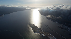
Transport Canada gives Enbridge nod for supertanker route
 Supertankers can safely carry huge volumes of oil sands crude through the winding waterways that connect Kitimat, B.C., to the open Pacific, a review by Transport Canada has concluded.
The review examined the marine passages that would allow the proposed Enbridge Inc.Northern Gateway pipeline to export Alberta oil to buyers in China and California. That $6.6-billion project has become one of the country’s most important industrial initiatives, backed by important energy producers and opposed by a raft of first nations and environmental groups.
Much of the opposition has stemmed from concern over spills in the waters off Kitimat, which is connected to the Pacific through a series of channels and sounds that will take between 10 and 16 hours for a supertanker to navigate. These concerns have been heightened both by the Exxon Valdez disaster, which devastated a similar coastal environment, and by several recent accidents, including the sinking of the Queen of the North ferry.
In its review, Transport Canada said Enbridge must set weather limits for tanker traffic, and look for newly identified hazards in marine charts that are being updated with modern technology.
But in a document posted Thursday by the National Energy Board, Transport Canada concluded that “the proposed shipping routes are appropriate for the oil tankers that will be used at the proposed terminal. … There are no charted obstructions that would pose a safety hazard to fully loaded oil tankers.”
The review points to a series of Enbridge safety pledges – including the use of tethered tugboats, the installation of new navigation aids and radar, and the vetting of vessels to ensure sub-standard ships aren’t used – that go beyond current requirements.
“Commitments by the proponent will help ensure safety is maintained at a level beyond the regulatory requirements,” Transport Canada found.
Although “there will always be residual risk in any project,” no concerns were found with the tankers that would be used, the way they would be operated, the routes they would sail or the traffic they would encounter.
Critics have pointed to a number of safety concerns for the huge oil-carrying vessels, including narrow, rock-lined marine passages, the regular occurrence of severe weather – fog, raging winds, massive waves – and the lack of suitable shelter in a storm.
For example, only one anchorage point has been approved for supertankers along the route. Even the waters off Kitimat, where the ships would be loaded, don’t offer enough room for a proper anchorage. Simulations conducted for Enbridge concluded that on some routes, even tugboats would be unable to keep a safe grip on tankers in the event of strong winds, above 75 kilometres an hour. Indeed, in those conditions, tethering lines would be expected to snap.
Some of the tankers that would sail into Kitimat far exceed anything seen on the coast before. Until now, the largest vessels calling on Kitimat have been 50,000-tonne tankers delivering condensate, an oil-thinning product imported by oil sands producers. Even in Prince Rupert, which has open-water access, the largest vessels to date have been 250,000-tonne carriers.
For Gateway, roughly 60 oil tankers a year would be very large crude carriers with a deadweight of 320,000 tonnes.
The Gateway project would bring a total of 250 new vessels a year. Proposed new natural gas terminals could bring that total to 415 “additional oil tankers, liquefied natural gas carriers and bulk carriers calling at Kitimat, or 830 additional transits of the waterways,” Transport Canada found.
But the agency concluded that the existing waterways could handle the increase in traffic, and that nothing would fall outside normal marine parameters. For example, 70-metre supertankers require a channel at least 490 metres wide. The narrowest point on the marine route is 1,470 metres. Supertankers would need a minimum water depth of 33.2 metres. The proposed routes – there are three, some longer, some better in rough weather – are 36 metres and greater.
Transport Canada does point out, however, one 35-metre area that can be “easily avoided” and a more worrisome 26.4 metre deep area that “must also be avoided.”
It offered 15 recommendations, many of which involved ensuring Enbridge provides shippers and terminal operators with books containing information on operating practices and port conditions. It also suggests Enbridge consult with local marine experts “to set environmental limits (weather and sea conditions) on oil tanker navigation associated with the project.”
You can return to the main Market News page, or press the Back button on your browser.

