Isaac Poised To 'Torment' New Orleans As Category 1 Hurricane On Anniversary Of Katrina
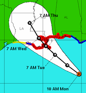
 The good news: Tropical storm Isaac veered away from Tampa. The bad news: It is taking aim at New Orleans and is on a path to deliver that beleaguered city a dangerous deluge and serious storm surge on the seventh anniversary of Hurricane Katrina.
Fortunately, Isaac does not appear likely to make landfall stronger than a strong Category 1 hurricane. Unfortunately, it is a large, slow-moving storm and poses real dangers that have already led to evacuation orders for parts of Plaquemines Parish, Jefferson Parish, and St. Charles Parish.
As meteorologist and former hurricane hunter Dr. Jeff Masters explained this morning, “The latest 8-day precipitation forecast from the GFS model calls for 10 – 20 inches of rain over much of Louisiana.” The biggest damage is expected to come from the storm surge, which could exceed 10 feet in places. Masters expects that based on its size and trajectory, “Isaac’s storm surge will be about 30% higher than the typical surge one would expect based on the maximum wind speeds.” He discusses the new levee system and concludes, “I expect New Orleans’ new flood defenses will be able to hold back Isaac’s surge, but areas outside the levees are at risk of heavy storm surge damage.”
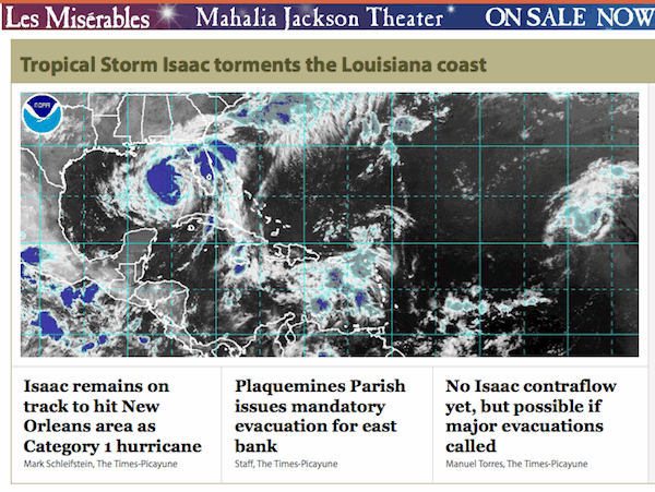
A good place to capture the mood of New Orleans and the latest updates on the storm is The Times-Picayune website, nola.com. Here’s the front-page noon Monday:

I wonder if the editors were being intentionally ironic by running that headline below an ad for the musical, Les Misérables. The citizens of New Orleans must feel as if hurricanes are hounding them like Inspector Javert.
Sadly, because of the obstructionism of one political party in particular, the most intense Gulf storms are all but certain to become increasingly destructive in the coming years. As Kevin Trenberth, former head of Climate Analysis at the National Center for Atmospheric Research, explained in the journal Climatic Change this year:
The answer to the oft-asked question of whether an event is caused by climate change is that it is the wrong question. All weather events are affected by climate change because the environment in which they occur is warmer and moister than it used to be….
The air is on average warmer and moister than it was prior to about 1970 and in turn has likely led to a 5–10 % effect on precipitation and storms that is greatly amplified in extremes. The warm moist air is readily advected onto land and caught up in weather systems as part of the hydrological cycle, where it contributes to more intense precipitation events that are widely observed to be occurring.
Global warming fuels more intense deluges from major storms like hurricanes. At the same time, warming-driven sea level rise makes storm surges more destructive. The latest studies find that staying near our current greenhouse emissions emissions path, leads to a foot of sea level rise by mid-century and over 40 inches of sea level rise by 2100 and then seas continue to rise 7 inches or more a decade!
Since much of New Orleans is already below sea level, its battle against deluges and storm surges represents the warming-driven future for all coastal cities in Hurricane Alley.
Since my brother lost his home in Katrina, and that ultimately led to my launching this blog on the one-year anniversary of Katrina, I follow hurricanes and hurricane science closely.
Here is an excerpt from my book, Hell and High Water, about Katrina and what is to come:
On August 23, 2005, a tropical depression formed 175 miles southeast of Nassau. By the next day, it had grown into tropical storm Katrina and was intensifying rapidly. Early in the evening on August 25, Hurricane Katrina made landfall near North Miami Beach. Even though it was only a Category 1 storm, with sustained wind speeds of about 80 miles per hour, it caused significant damage and flooding, and took 14 lives.
The hurricane’s quick nighttime trip across Florida barely fazed the storm. Entering the Gulf of Mexico’s warm waters quickly kicked Katrina into overdrive, like a supercharged engine on high-octane fuel. Hurricanes fuel themselves by continually sucking in and spinning up warm, moist air.
On August 28, Katrina reached Category 5 status, with sustained wind speeds of 160 mph and a pressure of 908 millibars. A few hours later, wind speeds hit 175 mph, which they maintained until the afternoon.
At 4:00 pm, the National Hurricane Center warned that local storm surges could hit 28 feet, and “Some levees in the Greater New Orleans Area could be overtopped,” a warning that was tragically ignored by federal, state, and local emergency officials. Over the next 14 hours, Katrina’s strength dropped steadily. When the hurricane’s center made landfall Monday morning, it was a strong Category 3, battering coastal Louisiana with wind speeds of about 127 mph. The central pressure of 920 millibars was the third lowest pressure every recorded for a storm hitting the U.S. mainland.
The devastation to the Gulf region was biblical. The death toll exceeded 1300. The damage exceeded $100 billion. [Combined with the effects of Hurricane Rita] two million people were forced to leave their homes, more than were displaced during the 1930′s Dust Bowl. One of the nation’s great cities was devastated.
About 20 miles to the west of the second Gulf landfall was the small town named Pass Christian, Mississippi, where my brother lived with his wife and son.
Tropical cyclones in the northern hemisphere rotate counterclockwise, and so the most intense storm surge is just to the east of the eye, because the surge represents the intense winds pushing the sea against the shore. A 30-foot wall of water with waves up to 55 feet crashed over the town. Although my brother and his family lived one mile inland, their house was ravaged with water up to 22 feet high, leaving the contents of the house looking like they had been churned “inside of a washing machine,” in my brother’s words. While they lost virtually all their possessions, they were safe in a Biloxi shelter.
Thanks to the generosity of many people, my brother’s family was able to find a temporary home in Atlanta. But like many families whose lives were ripped apart by the storm, they had difficult choices in the ensuing months. Perhaps the toughest decision was whether to rebuild their home or to uproot themselves and try to create a new life somewhere else.
I very much wanted to give my brother an expert opinion on what was likely to come in the future. After all, climate change was my field, and while my focus has been on climate solutions, I had done my Ph.D. thesis on physical oceanography.
As I listened and talked to many of the top climate experts, it quickly became clear that the climate situation was far more dire than most people–and even many scientists, myself included–realized. Almost every major climate impact was occurring faster than the computer models had suggested. Arctic sea ice was shrinking far faster than every single model had projected. And the great ice sheets of Greenland and West Antarctica were shedding ice decades earlier than the models said. At the same time, global carbon dioxide emissions and concentrations were rising faster than most had expected.
As for hurricanes, global warming had been widely projected to make them more intense and destructive. Since 1970, the temperature of the Atlantic Ocean’s hurricane-forming region has risen 0.5°C (0.9°F). Over the path of a typical hurricane, this recent ocean warming added the energy equivalent of a few hundred thousand Hiroshima nuclear bombs. On our current emissions path, the Atlantic will warm twice as much, another 1°C, by mid-century, and perhaps another 2°C beyond that by century’s end. Who can even imagine the hurricane seasons such warming might bring?
You can return to the main Market News page, or press the Back button on your browser.

