Climate: El Niño Stalls, Outlook Uncertain
 This year’s El Niño is likely to be one of the weaker versions of the event in recent memory, according to experts with the National Climatic Data Center, who discussed the fall outlook and reviewed the long, hot summer at teleconference last week.
That could weaken potential impacts, particularly across the southern tier of states, where an “average” El Niño often brings above-average precipitation.This could be especially important for states like New Mexico, which just experienced its driest and warmest 24-month period on record, and farther east, where Oklahoma was also parched during a record-hot summer.
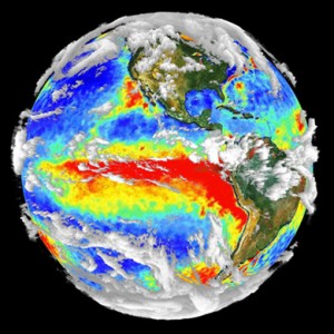
During an El Niño, sea surface temperatures in the eastern and central equatorial Pacific surge to above average, often shifting the storm track to the south. It’s part of a cyclical shift in sea surface temperatures and related wind patterns that can affect weather patterns worldwide.
Sea surface temps have hovered at slightly above average the past few months in the region where El Niño formation is measured, but haven’t reached the formal threshold yet. An area of cooler water in the north Pacific may be a factor.
The North Pacific is not cooperating … there’s a cold area near Alaska. It’s not quite a perfect setup for a warm event in the tropics,” said NOAA scientist Huug van den Dool.
“It’s probably too late to get a major El Nino … it’s going to be somewhat weaker than we expected a few months ago,” he said, explaining that there’s still a chance for enhanced precipitation across the South. An average El Niño footprint would normally also result in below-average precipitation in the northern tier of states.
A map from the National Climatic Data Center shows where the summer heat wave was centered. Click on the graphic to visit the NCDC online.
El Niño or not, the Climate Prediction Center says there’s a good chance the next three months will bring mostly above average temperatures to a big swath of the country, from the eastern edge of the Great Basin through the central and northern plains, up into the Great Lakes region and New England.
The three-month precipitation outlook is for near-normal total for much of the country, with a chance of above-normal rainfall in the southeast, and drier-than-normal conditions in the Pacific Northwest.
Looking back, Jake Crouch, of the NCDC, said it was the third-warmest summer on record for the U.S. and second-warmest summer for the northern hemisphere. A total of 33 states reported their warmest year to-date on record.
The year to-date is the ninth-warmest on record globally.
You can return to the main Market News page, or press the Back button on your browser.

