
Leaked map reveals Big Gas eyeing most biodiverse place on earth
Look at the map below. What it shows is a gas company’s interest in doing “geological fieldwork” at two UTM-referenced points in the far west of the Manu National Park in Peru’s Amazon:
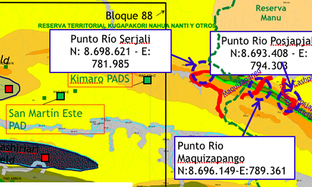
The map vaguely and ignorantly - or hopefully? Disdainfully? - calls Manu a “reserve”, where gas operations are permitted. Not so in national parks. Peru’s 1997 Law of Protected Natural Areas states “the extraction of natural resources is not permitted” in parks, while the 2001 regulations for “protected natural areas” states the “settlement of new human groups and the exploitation of natural resources is prohibited.” In addition, the 1993 Constitution “obliges” the government “to promote the conservation of biological diversity and protected natural areas.”
Manu isn’t just any national park. It is home to members of several indigenous peoples - the Matsigenka, “Matsigenka-Nanti”, “Mashco-Piro”, Nahua, Quechua and Yine - while UNESCO, which has designated it a biosphere reserve and World Heritage Site, says that the biodiversity “exceeds that of any other place on earth.” In early 2014 scientists described Manu as “top of the [world’s] list of natural protected areas in terms of amphibian and reptile diversity”, and back in 2006 other scientists found that the number of bird and mammal species is the “largest for any similarly sized area in the world.”
“For 10 years [Manu] has held the title as the world’s richest protected area for birds and mammals,” Bruce Patterson, from The Field Museum in the US, told the Guardian.
Peruvian NGO Ecodess featured the map above, titled “Geological fieldwork program 2011-Kimaro Manu”, in an April 2013 report. Why draw attention to it now?
First, because the company which drew it, Pluspetrol, was given permission last year to expand its operations eastwards within a concession called Lot 88, marked on the map too. If the Camisea gas project, as operations there are known, continues to expand eastwards - i.e. beyond Lot 88, where it doesn’t currently have permission to operate - it would eventually involve Manu. Indeed, the protected areas authority within the Environment Ministry, SERNANP, expressed concern that the 2014-approved expansion within Lot 88 would impact Manu indirectly by making the migration of “nomadic populations” living in what Peruvian law calls “isolation” between Camisea and Manu “frequent”, leading to “new settlements being established” in Manu and possible conflict with “indigenous communities” there. In an article of mine in Truthout, Pluspetrol played down such concerns, saying that the “nomadic populations” are “always coming and going” and such migrations are “characteristic of the way they live.”
Second, because of the current potential crisis situation in Manu’s buffer zone where, near the left bank of the upper River Madre de Dios, a group of indigenous people in “isolation” has effectively based itself since May 2011. The “Mashco-Piro”, as the group are known by many people, appear to usually base themselves much deeper, much more remotely in the park along right bank tributaries of the upper River Manu, avoiding contact and the potential transmission of fatal diseases. There are numerous possible reasons why this group is now where it is - e.g. internal division and/or loggers, colonists, narco-traffickers or other indigenous people entering their territories - but what about gas operations?
In addition to the oil and gas industry’s long-standing interest in Manu - to say nothing of Shell actually operating there in the 1980s - numerous reports and rumours have emerged from the region suggesting that one company or other has been there in recent years too. A 2014 report by NGO Peru Equidad states that people in the River Manu Chico region - immediately to the south of the two points marked for “geological fieldwork” on the map above - have been “disturbed” in recent years by overflights possibly “related to extractive projects”, and refers to claims reported by a Spanish Dominican priest based at the time in the larger Camisea region of “continuous helicopter flights towards the Manu headwaters” which suggested “seismic exploration or preparations for seismic” was taking place in the park.
Reports by the priest, now a bishop, David Martinez de Aguirre, on his blog are more detailed. In September 2010 he heard of “constant flights” to the headwaters of the River Kuria - a tributary of the upper River Camisea, most of which is outside Lot 88 - and in January 2011 he heard of “continued helicopter flights towards the Manu headwaters.” Three months later, in April, he was told by local inhabitants named “Regino, Mateo, Claudio and Marcos” that they had heard “chainsaws” in Manu and that “long, narrow criss-crossing paths running in different directions” were being made, with lots of “sogas” connected to other “sogas” - “soga” often translating as “rope” but which could refer to the cables used in seismic testing.
“They clearly didn’t know what this was about, but now in the lower [River] Urubamba region every Matsigenka knows when that happens it means that seismic testing is being done,” Martinez de Aguirre wrote, before asking - his capitals - “SEISMIC IN MANU?”
Note the date: April 2011. That’s to say, the month before the “Mashco-Piro” group effectively began to base itself along the upper River Madre de Dios to the east. Is this just an extraordinary coincidence, or might it be related? Were the “Mashco-Piro” pushed east out of the upper River Manu’s tributaries by whatever was reported in April 2011, or were other indigenous people pushed out which had a knock-on effect on the “Mashco-Piro”? Might Pluspetrol already have operated at or near one or both of the two UTM points, named “Point River Posjapjali” and “Point River Maquizapango”, or indeed anywhere else in Manu?
Pluspetrol’s interest in the River Maquizapango was previously revealed in a Guardian article of mine in February 2013 about a leaked report by Peruvian consultancy Quartz Services. The report states that in September 2011 Pluspetrol had applied for and been denied permission from SERNANP to enter Manu, but that Quartz could develop a strategy to obtain permission in the future. It reads:
Our mission, as an institution providing specialist technical services to Pluspetrol, will be to contribute not only to the continuation of activities in Lot 88, but also to the development of the Manu National Park protected area. Pluspetrol has plans to do geological exploration in the River Maquizapango region and/or its surroundings, an area to the east of the Lot [88] and inside the Manu National Park.
Pluspetrol’s immediate response to my Guardian February 2013 article was to issue a statement saying that it doesn’t have, and has never had, any interest in exploring Manu, and that it had wanted to do “superficial geological observations” there out of “scientific interest” which would involve “zero intervention with the environment.” When I asked it to clarify if it was claiming its intention to enter Manu had nothing at all to do with hydrocarbons and that it was motivated only by “scientific interest”, it stated that its “study of rocks in the River Maquizapango zone” was intended to contribute to the understanding of “Manu’s geological and historical evolution” and “Peru’s local and regional geology”, and the fruits of such research could be shared with “universities and other educational institutions” in the country. “In no way is this work associated with any extractive work outside Lot 88,” the company stated.
These claims regarding “scientific interest” were contradicted by Pluspetrol’s September 2011 request to SERNANP to enter Manu, which made no reference to any such interest. Indeed, ironically, SERNANP’s response to Pluspetrol refusing permission explained that only a very few activities are allowed in the part of Manu the company was interested in - one being scientific research.
The company’s September 2011 request to SERNANP makes it clear its only interest was hydrocarbons, although it is true it doesn’t state its intention is to exploit Manu per se. It states, rather vaguely, that it wants to study the “rock reservoirs in the Camisea area” by doing “geological fieldwork” in the “River Maquizapango zone”, and that this will “enable them to determine the presence or absence of rock reservoirs in the Lot 88 exploration area as well as define their physical characteristics.” “According to the wells drilled and seismic lines in Lot 88,” Pluspetrol stated, “the rock reservoirs that contain the gas run towards the eastern part of Lot 88. These rocks would appear on the surface in the River Maquizapango zone.”
According to Ecodess’s April 2013 report, the leaked map at the top of this article was also included in a version of the Quartz report revealed in my Guardian February 2013 article.
Pluspetrol did not respond to requests for comment.
You can return to the main Market News page, or press the Back button on your browser.