
Global December-February Temperature Warmest On Record
 (by Science Daily) — NOAA reports that February’s combined global land and ocean surface temperature was the sixth warmest on record, but a strong El Niño in January helped push the winter to its highest value since records began in 1880.
In the U.S., the December 2006-February 2007 winter season had an overall temperature that was near average, according to scientists at the NOAA National Climatic Data Center in Asheville, N.C. Precipitation was above average in much of the center of the nation, while large sections of the East, Southeast and West were drier than average. The global average temperature was the warmest on record for the December-February period.
Global Highlights
The combined global land and ocean surface temperature was the sixth warmest on record in February, but a record warm January helped push the winter (December-February) to its highest value since records began in 1880 (1.30 degrees F/0.72 degrees C above the 20th century mean). El Niño conditions contributed to the season’s record warmth, but the episode rapidly weakened in February, as ocean temperatures in the central equatorial Pacific cooled more than 0.5 degrees F/0.3 degrees C and were near average for the month.
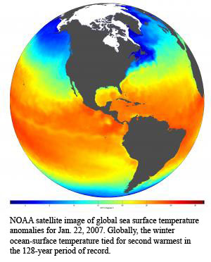
Separately, the global December-February land-surface temperature was the warmest on record, while the ocean-surface temperature tied for second warmest in the 128-year period of record, approximately 0.1 degree F (0.06 degrees C) cooler than the record established during the very strong El Niño episode of 1997-1998.
During the past century, global surface temperatures have increased at a rate near 0.11 degrees F (0.06 degrees C) per decade, but the rate of increase has been three times larger since 1976, or 0.32 degrees F (0.18 degrees C) per decade, with some of the largest temperature increases occurring in the high latitudes of the Northern Hemisphere.
U.S. Temperature Highlights
The winter temperature for the contiguous United States (based on preliminary data) was 33.6 degrees F (0.9 degrees C). The 20th century average is 33.0 degrees F (0.6 degrees C). Statewide temperatures were warmer than average from Florida to Maine and from Michigan to Montana. Cooler-than-average temperatures occurred in the southern Plains and areas of the Southwest.
The 11th warmest December on record occurred in 2006.
Upper-level wind patterns brought unusually cold weather to the southern Plains and much of the West in January. Snow and ice extended as far south as Arizona, southern California and south Texas. More typical winter conditions finally arrived in the eastern United States by late January and a period of colder-than-normal temperatures persisted through President’s Day weekend.
February was 1.8 degrees F (0.9 degrees C) below the 20th century average of 34.7 degrees F (1.5 degrees C), placing it in the top third coldest Februarys in the 113-year record for the contiguous U.S. Thirty-six states in the eastern two-thirds of the nation were cooler than average, while Texas and the eleven states of the West were near average to warmer-than-average.
The warmer-than-average winter temperatures in the Midwest and East helped reduce residential energy needs for the nation. Using the Residential Energy Demand Temperature Index (REDTI—an index developed at NOAA to relate energy usage to climate), the nation’s residential energy demand was approximately three percent lower than what would have occurred under average climate conditions for the season.
Seasonal energy demand would have been even lower, if not for February’s colder temperatures. For the month, temperature-related residential energy demand was approximately six percent higher than what would have occurred under average climate conditions for February.
For Alaska, both February (1.4 degrees F/0.8 degrees C) and winter (1.6 degrees F/0.9 degrees C) were warmer than average but far from the record warmth of 2003 and 2001, respectively.
U.S. Precipitation Highlights
Winter precipitation was above average from the Upper Midwest to New Mexico, Texas and Louisiana.
Several snow storms hit the Plains, Midwest and Northeast in February. One storm struck the mid-Atlantic and New England Feb. 14 and 15, and brought more than 20 inches of snow to widespread sections of the interior Northeast. This event was preceded by a 10-day lake effect storm that dumped more than 100 inches of snow on New York’s Tug Hill Plateau. A total of 141 inches was reported at Redfield in Oswego County.
Winter storms struck the Upper Midwest in late February and early March. Heavy snowfall, with record-breaking amounts, occurred from Feb. 23 through March 2.
Beneficial snows fell in the Sierras of California and the Great Basin Ranges in late February and early March, but the overall winter remained much drier than average. For all but the Northern Cascades and the Front Range of the Rockies in Colorado and New Mexico, seasonal snowpack was below average at the end of February.
Winter was drier than average from the Deep South to Kentucky, the mid-Atlantic, and along the Northeast Seaboard states. Much of the West also was drier than average. For February, precipitation was below average in the Southeast, Northeast and Midwest regions.
At the end of February, water-year precipitation in Los Angeles was the lowest on record, less than 25 percent of normal. According to the U.S. Drought Monitor, 25 percent of the continental U.S. was in moderate-to-exceptional drought at the end of February. The most severe conditions were in southwest Texas, northern Minnesota, Wyoming and the western High Plains.
Note: This story has been adapted from a news release issued by National Oceanic & Atmospheric Administration.
You can return to the main Market News page, or press the Back button on your browser.